AquaSoft Earth Pilot
7.2.2.0
Size: 8 MB
Downloads: 5737
Platform: Windows (All Versions)

The launch of Google Earth revolutionized the way maps are viewed. That's because this application provides detailed satellite images from around the world and also various images uploaded by users. But despite it's huge success, the Google Earth application has some downsides. One of them is the impossibility to automatically save all the photos from a current location, as the user is only able to view them. Secondly, one cannot record the animation generated by navigating from one point to another. Still, there is a utility that offers all these features. I am talking about AquaSoft Earth Pilot.
In order to work, AquaSoft Earth Pilot needs, of course, an operating system. Windows XP up to 7 will do. Secondly, the Google Earth plugin is needed in order to display the map. This can be obtained for free from the Google Maps website. Having all these requirements checked, it's time to launch the application.
After launching AquaSoft Earth Pilot, one will realize that its interface is simple to use and also intuitive. The user can navigate to a certain point on a map just by typing its name. While the map displays that spot, one can click on the Download images button and all the images regarding that place will be automatically listed and downloaded to the hard disk. This will save the user a lot of time and effort. Those photos can also be viewed online, not just downloaded.
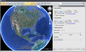
AquaSoft Earth Pilot allows setting a starting and ending point and recording the resulting animation as a file, while flying from a point to another. The animation can be previewed before it is saved. Besides that, its length can be adjusted by entering the number of seconds. Unfortunately, the video codec cannot be modified, and also the resolution, frame rate and bit rate can be adjusted.
The interface of AquaSoft Earth Pilot features some graphical buttons for display roads, 3D buildings or borders, in a similar way to Google Maps.
Pros
It can substitute the Google Maps application, by offering similar features in a lighter package. Besides that, it can automatically download all the images from a certain location to the hard disk and can also view them online. Furthermore, it can record the fly-by animation, from a point on the map to the other and can save it as a video file.
Cons
The animation can only be saved as an AVI file. AquaSoft Earth Pilot is an alternative to the Google Maps program, offering some interesting new features.
AquaSoft Earth Pilot
7.2.2.0
Download
AquaSoft Earth Pilot Awards

AquaSoft Earth Pilot Editor’s Review Rating
AquaSoft Earth Pilot has been reviewed by Jerome Johnston on 23 Mar 2012. Based on the user interface, features and complexity, Findmysoft has rated AquaSoft Earth Pilot 4 out of 5 stars, naming it Excellent